Red Rock Canyon.
After an hour and a half of driving we came upon this sight. It was the first inkling of what Bryce Canyon was going to be like. This is Red Rock Canyon just outside Bryce Canyon National Park. The bright blue skies, dark green trees & red-orange rock formations make for a nice setting. I even managed to get a shot with a bright red Mustang.
Bryce Canyon
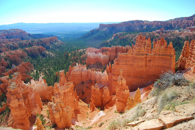
The photo above shows what Bryce Canyon is about. Multiple amphitheaters with 1000s of limestone spires. The limestone in the area is very soft and the elements are working very hard to tear them apart leaving an amazing array of strange shapes. This photo was taken from Bryce Point, which is one of many lookout points in the park. It looks back to Sunrise Point, Sunset Point and Inspiration Point. Bryce Canyon is the top tier of the Grand Staircase at 2900m above sea level, and the all lookout points look out over the lower plateau.Thor's Hammer
It may be a little hard to pick out in the photo above but there's a rock spire called Thor's Hammer.Sunrise Point
I took the photo above from Sunrise Point with the long lens. The typical colour strata in the rocks were particularly evident here. I like the almost Mars like look to this part of the canyon. The only thing that gives it away is the trees clinging to life in the crevices.
Inspiration Point
Inspiration point definitely follows the amphitheater mold.Check out the castle like formations in this photo. They are about as big as a castle as well.
The girls didn't look that inspired. I think they were a bit over orange/red rocks after four days of it. Besides, there was no crazy overhang to dangle off.
Bryce Point
Bryce Point is probably the biggest of the spiky amphitheaters. It is also the high point of the park at 8300 ft. At this elevation the trees do it tough. The weather is more brutal than even the Grand Canyon North Rim.Paria Point
Nothing too much to say about Paria Point other than it's a nice view as are most of the lookout points.Swamp Canyon
Swamp Canyon was much more heavily vegetated.Natural Bridge
Natural Bridge is yet another arch in Utah. Apparently it's been mis-named and should actually be called an arch, not a bridge.Agua Canyon
Agua Canyon is one of the prettier outlooks. We all liked the pink panther.Ponderosa Canyon
Rainbow Point
At the far southern extent of the National Park road is Rainbow Point. It has the widest view of all the lookouts.Black Birch Canyon
By the time we reached Black Birch Canyon, they were all starting to look the same.Another Long Drive
We had to leave Bryce Canyon fairly early because we had to drive some five hours north back to Salt Lake City. We stopped for lunch just outside the park gate and pigged out on a smorgasbord (thinking we may not have too many options for dinner, and we turned out to be right).I had borrowed a GPS off Shane which had proven pretty handy up until that point. I'd studied a local road map pretty carefully and saw a nice direct route back to Salt Lake City. The girl on the GPS didn't agree. She kept telling me to back track and take the long way. It was making me nervous, but I stuck to my guns. I figured that the GPS tries to take you along well maintained roads, not secondary farm access roads. This one was sealed, but we did come across a road block (above). It was a minor inconvenience considering the half hour it saved us on the drive.
The rest of the trip was fairly uneventful to the point of being dead boring. The land is very flat away from the southern part of Utah. The only point of note was that we were back in the city just in time for peak hour. For god fearing Mormons, they drive more like morons.
We handed back the keys to our trusty 4Runner and caught the evening flight back home. We're only in Calgary tonight and tomorrow night before we are off to the mountains.


