Tuesday, 26 September 2023

Mammoth Hot Springs - Upper Terraces


Upon arriving at Fort Yellowstone in the Mammoth area, we made our way to the dining room for lunch before setting off to explore the famed Mammoth Terraces.


We began our visit at the Lower Terraces, where elk lounged once again on the pale, mineral-coated steps—just as they had a few days earlier. 


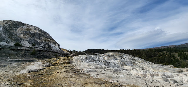
This area also marks the beginning of the boardwalk that winds its way up and around Minerva Terrace clinging to the hill above.


While Minerva Terrace itself felt somewhat underwhelming, the sweeping views overlooking Fort Yellowstone and the winding Gardiner River Valley, as it flows into the park from Montana to the north.


Near the trail’s end, you’ll find a vantage point overlooking Palette Springs—the thermal source responsible for feeding the brilliant white formations of the Lower Terraces.


After returning to the car, we made our way up the hill to the Upper Terrace Loop,that lets you view various geothermal features from the comfort of your vehicle. While many of the formations are relatively modest, one particularly striking highlight is Orange Spring Mound, which shimmered in the sunlight with vibrant, mineral-rich hues.


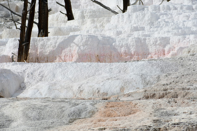
Angel Terrace stands out as another prominent feature of the Upper Terrace area. Its brilliant white mineral deposits are so strikingly bright, they could easily be mistaken for fresh snowfall.


Lamar Valley

The temperature dipped just below freezing overnight, making for a chilly start to the day. We hit the road early, eager to spot some wildlife (particularly bears and wolves) along the North East Entrance Road that meanders through the scenic Lamar Valley.

Dunraven Pass

To get to the Lamar Valley, we once again found ourselves winding through the steep yet picturesque Dunraven Pass. The crisp, clear morning offered stunning visibility from the various lookout spots along the route.


Tower Fall Close Encounter

Not far past the Tower Fall parking area, we were fortunate to spot a pair of mountain sheep grazing right next to the roadside.


We weren’t the only ones captivated by the sight—other wildlife enthusiasts had also gathered, hoping to snap close-up shots of these peaceful animals.

It was a rare and peaceful moment to be so near the mountain sheep, with neither the animals nor the people feeling uneasy or threatened.

Naturally, we managed to capture some incredible close-up shots of the mountain sheep.

Lamar Valley

After leaving the mountain sheep to graze undisturbed, we continued on to Tower Junction and turned onto the Northeast Entrance Road. Our original plan was to follow the route nearly all the way to Silver Gate, keeping an eye out for wildlife along the way. However, those plans quickly changed when we hit a construction zone that brought traffic to a standstill—with delays stretching over 30 minutes.

Forced to change course, we turned back and took a detour onto a side road that winds along Slough Creek. Almost immediately, our decision paid off—when we stopped at a nearby lookout, we spotted a large herd of bison grazing just a short distance away.

In contrast to the forested terrain of the Canyon area, the Lamar Valley is dominated by expansive grasslands—an ideal habitat that naturally draws the park’s massive bison herds.


We were fortunate to spot a coyote in the distance, intently hunting unseen prey across the open terrain.


Even with a long lens, capturing a clear photo of the distant coyote proved to be a challenge.


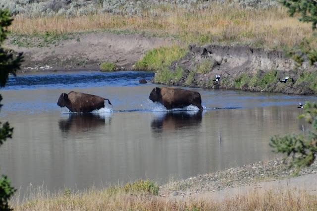
As the herd crossed the creek, they were followed by a family of magpies, either opportunistically snatching up insects stirred by the bison or defending their turf from the massive intruders.


As we watched the bison crossing the creek, we suddenly realized the rest of the herd had appeared from behind, much closer than expected.


Aware of the bison’s tendency for sudden aggression, we made sure to maintain a safe distance. The herd, undisturbed by our presence, continued on calmly as though we didn’t exist.


As we departed Slough Creek and made our way back toward Tower Junction, the bison once again took over the scene—this time by crossing the main road and triggering another unexpected traffic jam.


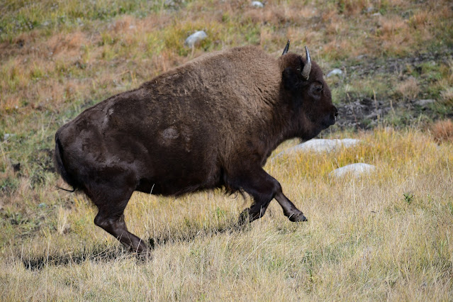
One of the big bulls walked straight in front of our car making me very nervous.


Eventually, the animals cleared the road and wandered off into the grasslands, resuming their routine undisturbed.


We continued on as well, quickly shifting our original plans, to return to the Mammoth Hot Springs area, where we had more to explore.


Just before reaching Mammoth, we paused to hike the short trail to Wraith Falls—one of Yellowstone’s many waterfalls and among the more easily accessible. Unfortunately, the falls were underwhelming, reduced to a mere trickle due to the dry season’s late-stage conditions. After a brief visit, we headed back to the car and resumed our journey to Mammoth Hot Springs.


Grand Canyon of Yellowstone (afternoon)

 Artist's Point


After lunch, we headed back to Artist’s Point in the Canyon, expecting the afternoon light to clear the shadows that had obscured our morning view. However, we quickly realized our assumption was off—the shadows remained. In hindsight, it made perfect sense, given that the canyon runs roughly west to east, limiting the sun’s reach into its depths throughout the day.


We spent time capturing more photos of the iconic Lower Falls, but also turned our lenses downstream, where the Yellowstone River has carved its way through the plateau, forming a dramatic and deeply incised canyon over time.


South Rim Trail


The South Rim Trail winds its way along the edge of the canyon, offering breathtaking views as it connects Artist’s Point with the Lower Falls. This scenic path allows hikers to take in the canyon’s vibrant walls and the thundering waterfall from multiple vantage points.


Along the South Rim Trail, we came across a variety of wildlife, including numerous squirrels and chipmunks (above) energetically gathering and hiding food in preparation for the rapidly approaching winter. Near the Lower Falls parking area, glossy black ravens put on a show of their own, hopping from tree to tree and squawking loudly—sometimes at passing tourists, other times at each other.


The final viewpoint along the South Rim Trail offers a stunning perspective of the Lower Falls, showcasing its powerful column of water as it plunges into the deep ravine below.


Upper Falls (above) is visible from a couple of convenient viewpoints near the Lower Falls parking area. While not as tall as the Lower Falls, it’s equally striking—its powerful flow fans out dramatically from the brink, surging with incredible speed and force.


We retraced our steps back to Artist’s Point and the car, and the change in perspective offered an entirely different scenic experience. This time, we were treated to expansive views of the Yellowstone River winding through the steep sandstone canyon walls.

Brink of Lower Falls


We returned along the access road beyond Upper Falls, crossing over to the North Rim for a completely new vantage point. The first viewpoint featured a steep, winding trail that led us down to the Brink of Lower Falls. The zigzagging trail was flanked by trees preparing for the coming winter, their leaves glowing gold in the afternoon sunlight and trembling softly in the breeze. 


The feeling that winter is near was unmistakable, stirring vivid memories of this same season in the Canadian Rockies. The crisp air, golden leaves, and quiet anticipation in the landscape echoed the familiar transition we’ve experienced before—nature slowly winding down in preparation for the long, cold months ahead.


From the viewing platform, we had a commanding view down the canyon, including a clear look at the South Rim Trail we had spent the past few hours exploring—now seen from an entirely different perspective.


The viewing platform brings you impressively close to the Lower Falls, offering a powerful sense of just how much water surges through this narrow section of the canyon. Standing there, you can feel the energy in the air—the roar, the spray, and the sheer force of the Yellowstone River as it plunges downward.


It's hard to fathom that part of this powerful torrent may have tumbled over the edge at Tower Fall just a day earlier.

North Rim Drive


From Lower Falls, we followed the one-way North Rim Drive, pausing at several scenic viewpoints along the route—starting with Lookout Point. While the view of Lower Falls is somewhat obscured from this angle, the overlook offers a beautiful glimpse downstream into the rugged, expanse of the Yellowstone Canyon.


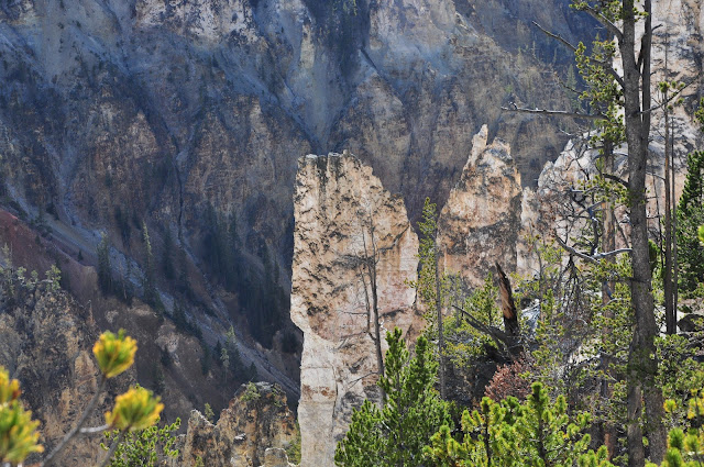
The next stop along North Rim Drive is Grand View, where the canyon truly lives up to its name. From this vantage point, you get a sweeping view of the heart of the Grand Canyon of the Yellowstone. The towering sandstone spires near Grand View are particularly striking—some so slender and gravity-defying, they seem almost impossible.


Interestingly, all the Yellowstone Canyon viewpoints share names with those on the Grand Canyon’s North Rim—including the final stop, Inspiration Point. From this lofty perch, we had a clear view upriver, where the Yellowstone River cascades down a series of small, steps carved into the canyon.


It had been a full and rewarding day spent exploring the Yellowstone River, from the calm shores of the lake to the dramatic depths of the canyon. As the sun dipped toward the western horizon, casting a golden glow across the landscape, we knew it was time to rest and refuel with a well-earned dinner.