Yesterday we flew down to Salt Lake City in Utah with Kerri's sister, Julie. We had a few dramas getting out of Calgary airport together. Julie's incoming flight from London was delayed and ended up cutting it fine to catch the connecting flight with us. Kerri tried to go and find her only to be the one about to miss her flight.
Today is the start of a week long epic circuit of the southern Utah national parks. We're then going back to Cowtown to take Julie on a four day whirl wind tour of the Canadian Rocky Mountain Parks.
We went to pick up our hire car from the airport which should have been a 5 door hatch of some sort. We were asked if we would like an upgrade (as they normally do) but we declined. Lucky we did because the agent then said, "We don't have the type of car you ordered so were are giving you a free upgrade to an SUV."
"Well... Ok, I suppose so." I said. Then they asked me which one. I couldn't help but pick the 4Runner. James has one and I've taken a liking to it over the last 12 months. This will definitely make our trip way more comfortable.
The photo above was taken this morning outside our hotel in Salt Lake City where we stopped overnight. It was the beginning of our 2500km road trip among the red rocks of southern Utah.
We had to get moving early because the drive to Arches National Park is nearly 400kms. There isn't much of interestenroute and we saw a lot of terrain much like that in the photo above.
Arches National Park
Just before we reached Moab the terrain changed and, before we new it, were at the entrance of Arches National Park.
Courthouse Towers
From the park entrance at the southern extremity of the park, the road winds up between sheer cliffs for short while. At the summit Park Avenue (above) is the first marked feature we saw. You can walk its length down to where the road sweeps around to meet the other end of the Avenue. We chose to keep going because there was so much to see today. We have some time tomorrow morning to come back so we put it on the list for the morning when it is nice and cool.
Park Avenue meets the road just behind the Three Gossips (above). The Three Gossips are one of the more interesting formations in the park. Little explanation is required for the name of this formation. Sheep rock faces the Gossips (right of picture).
Across the park access road from the Gossips is the Courthouse Towers. The Courthouse Towers seem a bit off track with the name to start with until you see the rock people at the top right of the feature.
Devil's Garden
After the initial excitement of some really interesting rock formations, we drove all the way out to the end of the northern access road that ends at the Devil's Garden (above). The garden contains three notable arches along with some impressive vertical faces that are only properly appreciated up close.
Just beyond the gateway is Tunnel Arch (above). If it was out in the middle of nowhere we would rave about for days after. Unfortunately, since there so many other amazing arches in the park, Tunnel Arch looses some of its grandeur.
Pine Tree arch is quite close to Tunnel arch and down the same side trail. As impressive as it is, in the context of Arches National Park, it rates as average. There is a small, weather beaten pine tree under the arch.
We back tracked along the side trail and saw a few puffs of cloud building up. We thought nothing of it at the time as it was getting pretty hot and we were in the middle of the US in a desert. More on that thought later.
This was a very abstract formation. It looks like the elongated face.
We didn't have time to hike the whole trail but we did make it to Landscape arch (above). Landscape Arch was one of my favourites today. The surrounding 'Landscape' frames the arch with longest span of any of the arches (88m).
By the time we passed back through the gateway the sun had made its mark. We all had varying degrees of sun burn and were already getting dehydrated. Back at the car we applied sunscreen and filed our water bottles.
Back tracking south along the road, we made a stop for Skyline Arch. It is one of the more picturesque arches and the sunny skies gave us the most incredible azure skies to offset against the burnt orange coloured rock formations.
Fiery Furnace
Delicate Arch
We were heading for the road junction in the middle of the park so we could take the eastern road out to Delicate Arch. A mile or so from the junction is the Fiery Furnace (above). I have absolutely no idea how the rocks formed over time in this park but they're nothing like anything I've seen in my travels.
To get a view of Delicate Arch, you have to take a short but steep trail up to a lookout point. The reward is obvious. Delicate arch is probably the most spectacular of the arches in the park. It The picture above with taken with a 300mm zoom lens and the scale of it is very hard to gauge without some sort of reference. There are two people in the photo to put some sort of perspective to it.
In the photo above, Delicate Arch is that little arch the the top left of shot. The enormity of the rock formations in the park really challenge the mind. It's well worth sitting at the lookout point for a few minutes to appreciate the surrounds.
Balanced Rock
From Delicate Arch we pressed back toward the middle of the park. Balanced Rock marks the spot in what appears to be slap bang in the middle of the park. It is one of the highest places in Arches NP so it seems appropriate. At that point we became more aware of the building storm clouds. It gave us a sense of urgency to keep moving. Despite that, we couldn't help but take a few silly tourist shots.
Garden of Eden
From Balanced Rock we headed for the Windows Section. About half way we stopped at the Garden of Eden. I'm not too sure where they got the name for this one but whatever the reason, I like the lone soldier sentry looking out over the park.
The Windows Section
The Windows section is a cluster of impressive formations. As you approach, Cove Arch (above) comes into full view.
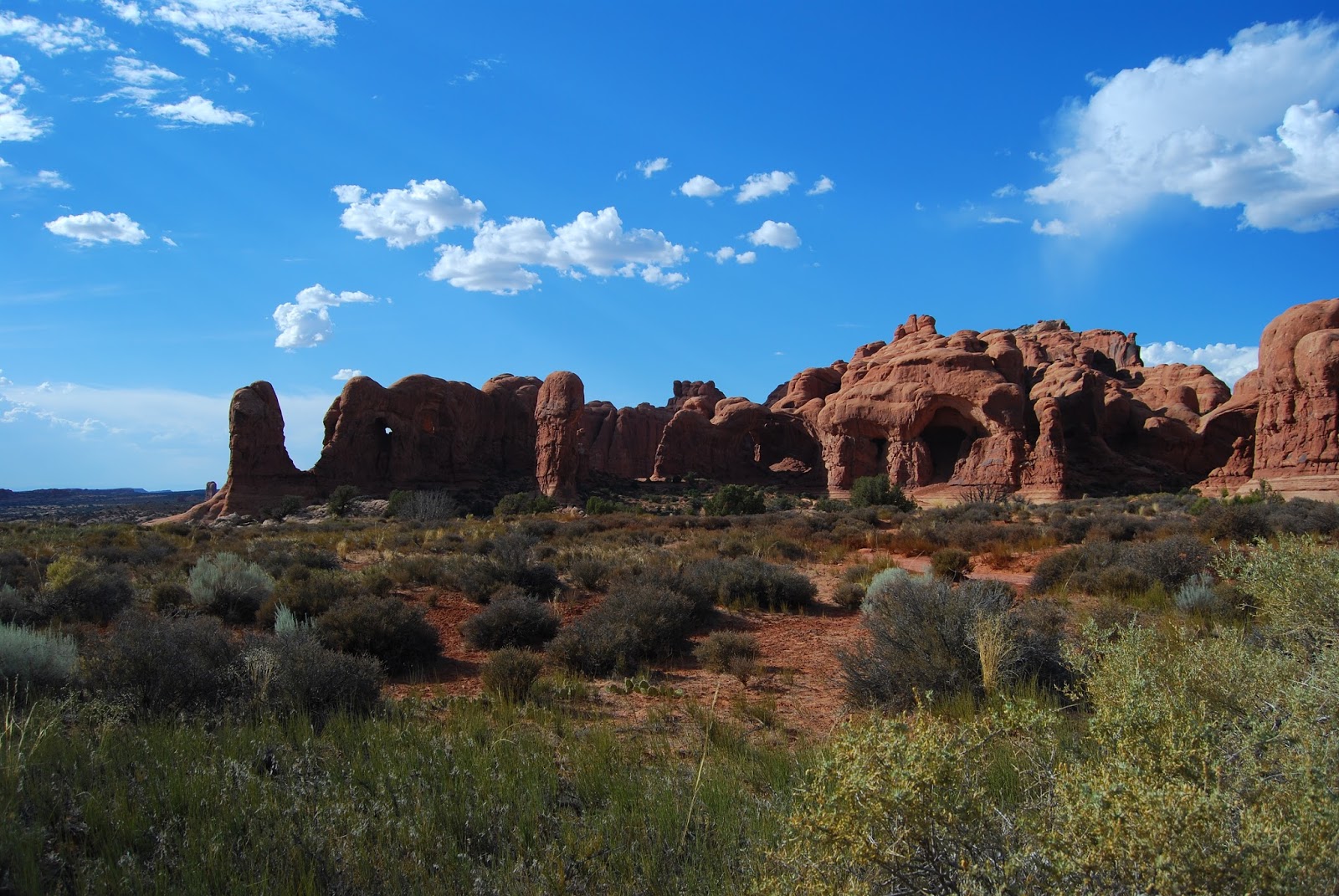
The Parade of Elephants. Kind of... The photo below makes it a bit more obvious.
Cove of caves.
Again, nothing too cryptic about the name for this one. Alone they are know as the North window & South Window. Together they are called the Spectacles. We went for a wander/scramble through the specs and Turret Arch.
Turret arch (above) is directly opposite the Spectacles. It is about the best place to take photos of the Spectacles.
Double Arch.
Double arch is in fact the one the the far left of picture. The second arch is set behind the one you can see & makes a V shape if you looked at it from above. We would have gone for a walk to get a better look but thought better of it. It was at the end of the day, it was pushing 40 Celsius, there was a nasty thunderstorm baring down on us and we were a bit arched out to be honest. The heat was making everyone a bit narky so we decided it would be best to head for the hotel. It was a good thing we did because the heavens opened shortly after and quenched the parched desert landscape.
We stayed the night in the small town of Moab. Judging by the vehicles parked in the main street the area is a magnet for serious four wheel drivers. We had a nice Mexican dinner before turning in for the night.