Today's weather has been average to say the least. Top temp today has been 11 deg C and raining. It reminded me of a typical winter's day in Perth. Cold, wet and windy. Basically miserable. The snag is that we are still a week out from the end of summer! It's similar weather to when we arrived in Canada back in the first week of June. No wonder the locals get so excited by summer!
Some of the trees have already started to turn yellow. Maybe a sign that nature knows exactly what's just around the corner.
I'm told we still have at least a month before things start to really serious and I hope they're right.
Sunday, 26 August 2007
Saturday, 25 August 2007
S.W.A.T.

Yesterday I headed down to the Ski shop again with the intent of setting myself up a bit better for Snowboarding in a little over two months. I was hoping to get gloves, goggles, a balaclava and a helmet. I didn't get the first couple, but I did get the last two.
I seem to have a habit of buying black clothing at the moment. Consequently I will look like a S.W.A.T. officer when I go snowboarding. So be it. Maybe the kids will stay out of my road when I'm boarding.
Sunday, 19 August 2007
House Plants
While we were doing a big shop (we have a car for the weekend), Kerri decided that we should have some house plants. She picked out the three pictured. Not the fanciest of plant types, but they should be pretty hardy. (I'm a little concerned about them getting enough light in winter.) We potted them up and set them up around the house. It should break up the endless white that's going to become second nature to us during winter.


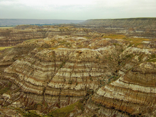
Drumheller
Today Shane and I headed out to Drumheller Valley.
Drumheller is the heart of Alberta Dinosaur country. The area is a bonanza for fossils. The Alberta prairies were at one time the bottom of the ocean and a lush rain-forest at another. The area is prime country for fossil deposits and, not coincidentally, petroleum and gas deposits.
The hour and a half trip out there is quite boring and the roads dead straight. The endless wheat fields and cattle paddocks were broken up by the odd farm house, wheat silo and "Donkeys". A Donkey is an oil well and they are scattered all over the place on the Alberta Prairies. Notice in the photo below, the flare stack in the background between the telegraph poles.

The Drumheller Valley was created by a glacier during the last ice age. All that remains of the glacier is the valley and the Red Deer River that runs through Drumheller. It's quite odd really, because you drive for an hour and half across the featureless prairie and then out of nowhere a great ravine appears.

Horseshoe Canyon (above), Horsethief Canyon (below), and most of the valley is very similar looking. The bonus for the bone hunters is that the bulk excavation has been done by nature exposing the rich fossil fields.
Unfortunately the weather was getting a bit wintery and the photos all came out hazy like these ones.
The first point of interest we came to was Horseshoe Canyon. I walked down to the floor of the canyon to have a bit of a nosy.
While I was there Shane spotted some movement near me. I managed to get pretty close and snapped a couple of shots. This little creature is about the size of my hand including its tail, but it was fast! It looked much like the ground squirrel from the previous day, but with a much longer tail and pointy nose. I had no idea what it was at the time. Fortunately, Wikipedia had some answers. As it turns out, this busy little creature is a Least Chipmunk.

The whole point of going out to Drumheller is to visit the Royal Tyrrell Museum.
The Royal Tyrrell houses most of the fossil finds from Alberta's Badlands (Drumheller and Dinosaur Provincial Park 150km to the south east). It is reportedly the world's best Fossil Museum in the world. I'll caution that in North America, "The World" could mean just North America. I will say it's pretty impressive and they use the actual fossils, not replicas like most museums use.
This photo is a T-Rex. Pretty intimidating when you stand next to it.

It should be noted that The Royal Tyrrell isn't a dinosaur museum as much as a fossil museum. They have laid it out so that you start with the most ancient fossils (such as the one pictured) and as you work your way around you trace the steps of evolution right through to present day.
The shell pictured is a brilliant example of the animal fossil being replaced by minerals to produce a beautiful gem.

The early exhibits include the first amphibians like the one pictured. These were some of the first vertebrates to walk the earth.
I didn't do too much reading of the information on the exhibits due to the hoards of people. Luckily I had Discovery Channel back in Oz and used to watch Paleoworld. These days I have a fairly sound knowledge of prehistoric evolution.

Dimetrodon is a member of the pseudo-mammals that are descended from reptiles. They're a separate branch to Dinosaurs and eventually gave rise to mammals. These ones are very cool and have the big sail on their back. A theory is that they used the sail to control blood temperature (a mammalian trait).

Here's one of the classics. Stegosaurus!
Anyone who hasn't heard of a Stegosaurus has got to be kidding me.

Another classic. There are four dinosaurs that everyone remembers. T-Rex, Brontosaurus, Stegosaurus and this one, Triceratops. Brontosaurus was notable by its absence, but the others were all there.

I couldn't help but post this one. Notice my snap happy mate, Shane in the right of shot. Usually Kerri's pocket digital camera is a match for Shane's DSLR with the postcard shots, but when you are in low light and need a wider angle, the expensive gear wins all the time.

The exhibits go right up to near present day. The mammoth is one of a number of animals from the Pixar movie "Ice Age" that were on display. Notice the sabre tooth tiger toward the back of shot.
I think I'll have to go back when there aren't so many people/kids at the museum and spend some time soaking it all in properly.

The Hoodoos are supposedly a major geographic wonder. Really?? I immediately saw it and said to Shane, "If that's it, I'm going to feel ripped off". Sure enough, that was it and I did feel ripped off. I said to Shane, "It reminds me of Piss Weak World".
The most disappointing thing is that these structures are so fragile and the parks people let people walk all over them (well mostly). There's even graffiti on them.

In all, a worthwhile day out in the prairies.
Drumheller is the heart of Alberta Dinosaur country. The area is a bonanza for fossils. The Alberta prairies were at one time the bottom of the ocean and a lush rain-forest at another. The area is prime country for fossil deposits and, not coincidentally, petroleum and gas deposits.
The hour and a half trip out there is quite boring and the roads dead straight. The endless wheat fields and cattle paddocks were broken up by the odd farm house, wheat silo and "Donkeys". A Donkey is an oil well and they are scattered all over the place on the Alberta Prairies. Notice in the photo below, the flare stack in the background between the telegraph poles.

Drumheller Valley
The Drumheller Valley was created by a glacier during the last ice age. All that remains of the glacier is the valley and the Red Deer River that runs through Drumheller. It's quite odd really, because you drive for an hour and half across the featureless prairie and then out of nowhere a great ravine appears.

Horseshoe Canyon (above), Horsethief Canyon (below), and most of the valley is very similar looking. The bonus for the bone hunters is that the bulk excavation has been done by nature exposing the rich fossil fields.
Unfortunately the weather was getting a bit wintery and the photos all came out hazy like these ones.

The first point of interest we came to was Horseshoe Canyon. I walked down to the floor of the canyon to have a bit of a nosy.
While I was there Shane spotted some movement near me. I managed to get pretty close and snapped a couple of shots. This little creature is about the size of my hand including its tail, but it was fast! It looked much like the ground squirrel from the previous day, but with a much longer tail and pointy nose. I had no idea what it was at the time. Fortunately, Wikipedia had some answers. As it turns out, this busy little creature is a Least Chipmunk.

Royal Tyrrell Museum
The whole point of going out to Drumheller is to visit the Royal Tyrrell Museum.
The Royal Tyrrell houses most of the fossil finds from Alberta's Badlands (Drumheller and Dinosaur Provincial Park 150km to the south east). It is reportedly the world's best Fossil Museum in the world. I'll caution that in North America, "The World" could mean just North America. I will say it's pretty impressive and they use the actual fossils, not replicas like most museums use.
This photo is a T-Rex. Pretty intimidating when you stand next to it.

It should be noted that The Royal Tyrrell isn't a dinosaur museum as much as a fossil museum. They have laid it out so that you start with the most ancient fossils (such as the one pictured) and as you work your way around you trace the steps of evolution right through to present day.
The shell pictured is a brilliant example of the animal fossil being replaced by minerals to produce a beautiful gem.

The early exhibits include the first amphibians like the one pictured. These were some of the first vertebrates to walk the earth.
I didn't do too much reading of the information on the exhibits due to the hoards of people. Luckily I had Discovery Channel back in Oz and used to watch Paleoworld. These days I have a fairly sound knowledge of prehistoric evolution.

Dimetrodon is a member of the pseudo-mammals that are descended from reptiles. They're a separate branch to Dinosaurs and eventually gave rise to mammals. These ones are very cool and have the big sail on their back. A theory is that they used the sail to control blood temperature (a mammalian trait).

Here's one of the classics. Stegosaurus!
Anyone who hasn't heard of a Stegosaurus has got to be kidding me.

Another classic. There are four dinosaurs that everyone remembers. T-Rex, Brontosaurus, Stegosaurus and this one, Triceratops. Brontosaurus was notable by its absence, but the others were all there.

I couldn't help but post this one. Notice my snap happy mate, Shane in the right of shot. Usually Kerri's pocket digital camera is a match for Shane's DSLR with the postcard shots, but when you are in low light and need a wider angle, the expensive gear wins all the time.

The exhibits go right up to near present day. The mammoth is one of a number of animals from the Pixar movie "Ice Age" that were on display. Notice the sabre tooth tiger toward the back of shot.
I think I'll have to go back when there aren't so many people/kids at the museum and spend some time soaking it all in properly.

The Hoodoos are supposedly a major geographic wonder. Really?? I immediately saw it and said to Shane, "If that's it, I'm going to feel ripped off". Sure enough, that was it and I did feel ripped off. I said to Shane, "It reminds me of Piss Weak World".
The most disappointing thing is that these structures are so fragile and the parks people let people walk all over them (well mostly). There's even graffiti on them.

In all, a worthwhile day out in the prairies.
Saturday, 18 August 2007
Kananaskis Country
I hired a car for the weekend again. I am onto the cheap weekend deals now. You can hire a car for about $26 per day plus insurance. It makes it pretty affordable but I still need to get myself a car.
So today we set off early (too early for Kerri) and headed out toward Banff. Instead of doing our usual trek to Banff & Lake Louise, we turned off just before the mountains & headed south into Kananaskis country. It is a provincial park, not a national Park. The difference is that you don't need to pay for a parks pass & the government seem to have a dam on every lake.
There are a bunch of camping spots along the road (Route 40).

The one that was most noteworthy was near the Nakiska ski resort, called "Beaver Ponds". It isn't too hard to work out where the name came from. There are a number of these beaver dams (I assume they are real beaver dams) in the area. We didn't see any of the local residents, but they only come out at night or dawn & dusk.

The Kananaskis Trail (Route 40) has nowhere near the spectacular scenery of the Icefield Parkway, but it is worth a sticky beak anyway. The road runs north-south along the first valley into the Rockies. It's flanked on both sides by sharp mountain ranges like the one pictured (Kananaskis Range). They all look grey & dirty like the one pictured and, as for the Icefield Parkway, are not particularly nice looking at this time of year. I'm very keen to have a drive through here when there is some snow on the peaks. Another month or so should do it.

We were about to turn off to the road that runs along beside the Kananaskis lakes when Kerri spotted some wildlife beside the road, right at the turn off. This mob of Big Horn Sheep were just going about their business beside the road. They aren't the prettiest animals, but they are native & protected in the parks. I didn't see any of the males with the rally big horns amongst this lot.

The Upper & Lower Kananaskis lakes are probably the highlight of the drive through Kananaskis Country. They have the turquoise tint to them that the lakes in Banff National Park epitomise. The lower lake (below) is the longer of the two and appears to be quite a popular fishing spot. The upper lake feeds into it via a Hydro-electric generation plant located just to the left of picture
It's not bad, but when you compare it to the Glacial Lakes in Banff National Park, it just isn't in the hunt.
Note the ranges left and right as far as the eye can see.

The Upper Lake is the prettier of the two with some rugged peaks behind it & a some more interesting vegetation & shoreline. The peaks in picture still have some traces of ice left as they don't get much sun even at this time of year. Again this lake is pretty popular with the fisher folk.

Kerri and I were walking along the dam wall of the Upper Kananaskis lake admiring the view. I had dropped behind a little when I saw some movement out of the corner of my eye.

I had seen one of these Golden-mantle Ground Squirrels at Moraine Lake a few weeks back. This one was ultra-cheeky. I stopped to have a look and grabbed the camera. While I was fumbling around with the camera, he came up really close to me. I snapped off a couple of picks & crouched down. He came right up and I held my hand out. He actually put his front feet up on my fingers. I suspect he had been fed by tourists before because he scuttled off all disappointed when there was nothing to offer. He came back a couple of times after that. I guess he either had a short memory, or was just hoping he'd get a different result.
I have always been an animal lover and a close encounter with any kind of wild creature, big or small, has always been a thrill. It made my day.

Today's trip started and ended in Calgary. We headed West on the Trans-Canada to the mountains, then South along Kananaskis Trail. We had to get back to Calgary through farmland to the SW of the city for about 75 kms. Along the way we saw the typical farms that you see anywhere on the prairies.
About 3/4 of the way back we saw a bunch of people parked & out of their cars looking at a little pond. I didn't know what it was all about, but eventually saw movement at the edge of the pond. By the ears & the head, I instantly knew what it was.

If you hadn't guessed already, you will know now. This young moose added another tick box to the Canadian animals we've seen so far. I'm guessing he/she is a bit over a year old. I'm not a moose expert, but I wouldn't be surprised if it was its first season away from its mother.
It was the last place I expected to see one of these animals & was under the impression that they only lived north of the North Saskatchewan River. How wrong I was. I'm guessing we were about 40kms south of Calgary.
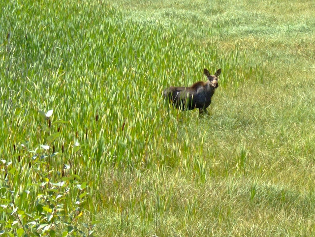
This picture reminded me of the TV show set in the north of Alaska called "Northern Exposure". The start of the show had footage of a moose walking down the main street.
I'm sure we'll get to see more Canadian wildlife in a couple of weeks when we spend four days in and around Banff. (I have another four day weekend coming up.).

Saturday, 11 August 2007
A Lesson in Layering
We've had such a good run with weather for the last 6-8 weeks. Most days have been in the High 20's or low 30's. Occasionally we have a thunderstorm in the evenings too cool things off. All rather pleasant really.
Over the last week we've had much cooler conditions, more like our first week or two after we got here. Colder temps & more rain are hinting that winter is not far off. The hints led us to the winter clothing store to buy some warm gear. Now is the time because everything in the winter lines were reduced by half in most cases.
Now for the lesson. The key to staying warm in minus stupid (as in other cold climates around the world) is LAYERS. It's particularly important in Calgary because of the huge temperature fluctuations (yes, even more than Melbourne). It can go from 25 above to 25 below within hours during winter. You have to have options with you to be prepared for the different conditions.
So you start with something synthetic against the skin. Apparently, this stops sweat from freezing close to your body.

Then you need something mid range to protect you from +5 to -10.

Finally there's the top layer which is the weather proof & warm. It also has a hood to keep the icy winds away from the head. They call this a shell and is crucial when it gets properly cold.

You can use all sorts of combinations of the three, but the use of all three with protect you from -20 & below (minus stupid). The same principal applies for the legs.
Sunday, 29 July 2007
Banff Lakes
On Sunday we'd had enough driving after covering 1200kms over the previous two days. We decided to do a bit of exploring close to Banff. Cascade Ponds (pictured) is about 3 kms from Banff's main street. Nice enough I guess, but I wasn't jumping up and down to go for a swim.

Just beyond Cascade pods is Lake Miniwanka (pronounced Miniwonka). We decided to go for a bit of a hike (3 kms each way) along the edge of the lake and up a gorge. Having been lucky with the weather conditions the previous two days, it finally gave way to haze. The forest fires burning in BC had made it a less than spectacular viewing day. You can see the haze in the photos.
Lake Miniwanka is a popular camping area but is also the place where a female hiker was killed by a female grizzly the week before. There is nothing more aggressive and dangerous than a female grizzly with cubs. The hiker was walking through a blackberry grove where the bears were feeding, startled the mother bear and paid the ultimate price. Most hikers at this time of the year carry a bell on them so the bears can hear them coming from way off and don't get surprised. Walking in groups of six or more also reduces the risk to next to nothing. The more noise you make, the more likely the bears are to take off, or at the very least, don't get startled.

Another tick in the wildlife box.
Big Horn Sheep are another native animal on the parks list. The females look like overgrown goats and the males have the huge horns you see in the photo below. They're a bit ugly in summer and I don't understand the hype surrounding them. Having said that, I'd like to see a couple of males having a head butting session.
It's not a great photo, but it's definitely the animal's better side.

Stuart Canyon
This was the purpose of the 3km hike. Stuart Canyon. It's one of the many streams that flow into Lake Miniwanka. We ended up hiking along the right hand side of this canyon to the fork in the stream. It wasn't overly interesting beyond the bridge we stood on to take the photo below and the mosquitoes were horrendous! They are huge and nearly bite off a limb when they have a go. We had to keep moving otherwise they would carry us off. The bears were far from our minds when the mozzies were about. Mental note to "remember the Aerogaurd & 'av a good weekend" next time.

Unfortunately our little national park tour had to come to an end so we headed for home. Work tomorrow & all that reality bites stuff.
Saturday, 28 July 2007
The Icefields Parkway
Saturday morning we set off for the Icefields Parkway early in the morning to try to keep ahead of the tourist buses & camper-vans. We stayed only just ahead of the crowd for most of the day. The Icefields Parkway runs from Lake Louise north to Jasper, some 237 km. The Parkway spans both Banff & Jasper National Parks. The drive itself is quite spectacular before you even stop to see the Rocky Mountain gems.
The first major point of interest along the Parkway is the Crowfoot Glacier. The name comes from the three branches of the glacier that make it look like a crow's foot. The left hand/lower branch has receded in recent years like glacier's the world over leaving only the two branches today.

Bow Lake was by far the most spectacular view along the Icefield Parkway on the trip north. You can see that early in the morning when the sun isn't too bright & the wind is non-existent, the photos come up a treat. The lake was so still that the reflection masks the Turquoise colour of the lake. We took ten photos of this lake & not one of them is a bad shot.

All along the Parkway, there are roadside stopping areas so you can pull up & have a look & take some photos. Still at Bow Lake, I had to go one better for this one. I thought it would be clever to cross the road & climb part the way up the hill opposite the lake. I got the shot, but also got nailed by the mosquitoes! They are huge over here! I guess it comes from feeding on deer & bears......

Below is the best photo of the day (and maybe the weekend) and another of Bow Lake. I don't think much else needs to be said.
The ice flow in the centre of picture is Bow Glacier.

One more from Bow Lake. It's a little easier to pick up the turquoise colour of the lake.
The little red dot in the centre of picture is actually a Num-Ti-Jar Lodge. You can stay there for about $300 CAD per night in summer time. A bit on the expensive side, but what a view to wake up to in the morning! Bow Lake also freezes in winter as do most of the lakes in the Rockies.

We stopped here on the way back from Jasper later that day. There was no reflection and the sun had gone to the far side of the lake. To be honest, it was fairly uninteresting. I'd really like to see some of the other lakes further to the north in the early morning with no breeze.
Peyto Lake
This photo of Peyto Lake is taken from the lookout at Bow Pass.
Bow Pass is the highest point on the Icefield Parkway at 2067 m above sea level. Calgary sits quite high at about 1050 m, so Bow Pass is quite high up. The lookout is about 30m higher than the pass itself. The walk to the lookout isn't that far, but the altitude means you get out of breath quite quickly. I can see how people get into trouble in the mountains.

Waterfowl Lake & Mt Cephren
Yet another of Banff National Park's beautiful Turquoise Lakes and the most northern one we saw. Once you get west of the Continental Divide or north of the North Saskatchewan River, the blue in the rivers & lakes, miraculously disappears. The rivers change to a milky grey & the lakes seem to all be more of a green tinge.
The first 75 kms from Lake Louise are the most picturesque of the entire 237 kms journey with a bunch of lakes, rivers, mountains & glaciers to see. If you aren't to keen on the long drive to Jasper, I would advise concentrating on the points of interest at least up to this point.
The Mountain Peak behind is Mount Cephren. I just can't help but take pictures of blue lakes with mountain reflections & there are stacks to choose from in the mountains around here.

North Saskatchewan River
You can see what I mean about the rivers loosing the blue colour once you hit the North Saskatchewan River. This shot is taken from in front of the weeping wall. The wall is mildly interesting, but you end up too close to it to take a decent photo. Also it was in shadow.
This shot is semi-typical of the outlook from the road as it runs through the valley all the way to Jasper. It may be typical, but it's forever changing & never boring.

Bridal Veil Falls
As the road climbs the escarpment at the end of the valley above, there's a rest area with a view of Bridal Veil Falls (below), one of many waterfalls along the parkway.

Athabasca Glacier
This is the No. 1 tourist trap on the Icefields Parkway.

The Athabasca Glacier is the visual part of the Columbia Icefield that stretches 75kms north West into the Rocky Mountains. To be honest, the Athabasca Glacier isn't that spectacular although I am half keen to take a helicopter or light plane flight over the icefield. I am told the glaciers on the NZ south island are much more impressive. (I'll get back to you on that one someday).
Having said all that, the view from the visitor centre is pretty impressive with Parker Ridge to the left (first picture) and the Stutfield Glacier to the right (second photo).


We were lucky to have brilliant blue skies for most of the day. The next day the haze from the forest fires took over.
Tangle Falls is the most interesting of all the water falls along the Icefields Parkway (and there are many). Many drive past them unaware after heading off from the Icefields Centre. I've seen photos of these falls when they're iced up. I'm thinking a trip along the Parkway in winter is something we should do before we leave Canada.

There's a lengthy stretch without much of significance until you reach Sunwapta falls (below) about 55kms short of Jasper. To be honest, we were a little disappointed in them after Takakkaw falls the previous day but they're still well worth a look.

A sort way further north the Athabasca Falls have the largest volume of water of any of the falls in the Rockies. This one is very popular with the tourist buses.

After leaving Athabasca Falls, we headed down the 93A which is a road that runs parallel to the main parkway road. It services a couple of little lakes & a few camping grounds.
So we came around a bend & this is what we saw. Black bears are a lot smaller than their grizzly cousins, but are no less dangerous. This guy was just wandering along the road, looking for things to eat.

Cautiously we drove up alongside the bear as he walked along. He didn't seem too concerned about our presence and went about his business. It was fantastic to even sight a bear, let alone get this close to one.

Our new friend kept digging around on the side of the road looking for food. I don't know what he was after, but he found plenty of whatever it was.
A very cool close encounter. Can't wait to see more animals & there is no shortage of them in Canada & they are out in the daytime!

Footnote: Two things you do not do with bears of any type. Approach them or back them into a corner. They don't like getting threatened & have mauled people who do exactly that. Not long after our bear sighting, we came up to a campground & saw a commotion of some sort. It turned out to be another bear that was feeding on something. Sure enough there were 6 idiot tourists with cameras converging on the animal doing exactly what you shouldn't do with bears...... Some people are just not very bright.
The animal spotting continued. You may remember the Bull Elk we spotted next to the Bow Valley Parkway about a month ago. Well, just outside Jasper, we spotted this Elk doe beside the road, just kicking back chewing its cud. Another tick in the box.

Medicine Lake is similar to many of the lakes around Alberta. It has more of a green tinge to it than the ones in Banff National Park as do most of the lakes outside Banff National Park.
Medicine Lake has a difference. It has no exit stream like most lakes, it has sink holes where the water flows into an underground system nearly all the way down to Jasper and empties into the River in the valley below. In the drier months, the lake actually empties leaving a plateau with some small pools.

You may have seen a photo of a Ground Squirrel in a previous entry. They are everywhere in Calgary. When you go into the National Parks, you see them everywhere as well, but they are a different type. Apparently these little guys are the true native gopher called the Columbia Ground Squirrel. Instead of being a drab brown colour like their prairie cousins, they are blue & orange. They're quite a bit bigger as well.

We refueled the car in Jasper and headed back to Banff. The cloud had started to close in and the winds was up so the spectacular photographic conditions from the morning were a distant memory. We didn't stop more than for a couple of comfort stops on the way. We were pretty glad to be out of the car by the end of it but made a plan to return to Jasper soon.
Subscribe to:
Posts (Atom)