Thursday, 28 August 2008

Bryce Canyon

We stayed in Cedar City over night (not too much of note there), and with another long day on the road, we set off early. This morning the main focus was Bryce Canyon.

Red Rock Canyon.


After an hour and a half of driving we came upon this sight. It was the first inkling of what Bryce Canyon was going to be like. This is Red Rock Canyon just outside Bryce Canyon National Park. The bright blue skies, dark green trees & red-orange rock formations make for a nice setting. I even managed to get a shot with a bright red Mustang.

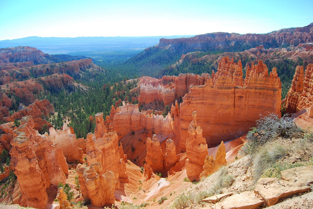
Bryce Canyon

The photo above shows what Bryce Canyon is about. Multiple amphitheaters with 1000s of limestone spires. The limestone in the area is very soft and the elements are working very hard to tear them apart leaving an amazing array of strange shapes. This photo was taken from Bryce Point, which is one of many lookout points in the park. It looks back to Sunrise Point, Sunset Point and Inspiration Point. Bryce Canyon is the top tier of the Grand Staircase at 2900m above sea level, and the all lookout points look out over the lower plateau.

Thor's Hammer

It may be a little hard to pick out in the photo above but there's a rock spire called Thor's Hammer.

Sunrise Point

Sunrise point was one of the first lookout points we went to. From there you get to see some of the strange formations at close range.
I took the photo above from Sunrise Point with the long lens. The typical colour strata in the rocks were particularly evident here. I like the almost Mars like look to this part of the canyon. The only thing that gives it away is the trees clinging to life in the crevices.

Inspiration Point

Inspiration point definitely follows the amphitheater mold.
Check out the castle like formations in this photo. They are about as big as a castle as well.
The girls didn't look that inspired. I think they were a bit over orange/red rocks after four days of it. Besides, there was no crazy overhang to dangle off.

Bryce Point

Bryce Point is probably the biggest of the spiky amphitheaters. It is also the high point of the park at 8300 ft. At this elevation the trees do it tough. The weather is more brutal than even the Grand Canyon North Rim.

Paria Point

Nothing too much to say about Paria Point other than it's a nice view as are most of the lookout points.

Swamp Canyon

Swamp Canyon was much more heavily vegetated.

Natural Bridge

Natural Bridge is yet another arch in Utah. Apparently it's been mis-named and should actually be called an arch, not a bridge.

Agua Canyon

Agua Canyon is one of the prettier outlooks. We all liked the pink panther.

Ponderosa Canyon

Rainbow Point

At the far southern extent of the National Park road is Rainbow Point. It has the widest view of all the lookouts.

Black Birch Canyon

By the time we reached Black Birch Canyon, they were all starting to look the same.

Another Long Drive

We had to leave Bryce Canyon fairly early because we had to drive some five hours north back to Salt Lake City. We stopped for lunch just outside the park gate and pigged out on a smorgasbord (thinking we may not have too many options for dinner, and we turned out to be right).

I had borrowed a GPS off Shane which had proven pretty handy up until that point. I'd studied a local road map pretty carefully and saw a nice direct route back to Salt Lake City. The girl on the GPS didn't agree. She kept telling me to back track and take the long way. It was making me nervous, but I stuck to my guns. I figured that the GPS tries to take you along well maintained roads, not secondary farm access roads. This one was sealed, but we did come across a road block (above). It was a minor inconvenience considering the half hour it saved us on the drive.
The rest of the trip was fairly uneventful to the point of being dead boring. The land is very flat away from the southern part of Utah. The only point of note was that we were back in the city just in time for peak hour. For god fearing Mormons, they drive more like morons.

We handed back the keys to our trusty 4Runner and caught the evening flight back home. We're only in Calgary tonight and tomorrow night before we are off to the mountains.

Wednesday, 27 August 2008

Zion National Park

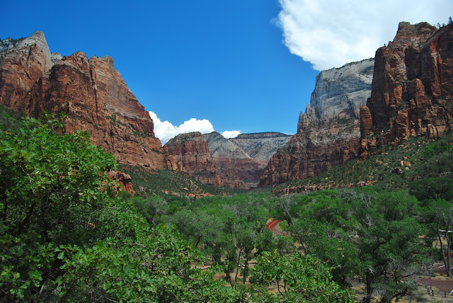
This morning we said good-bye to Page as we crossed the Glen Canyon bridge. We set out West along the UT/AZ border and a couple of hours later arrived at Zion National Park. Zion is one of the real gems of the multitude of national parks in the area. It forms a water catchment for the surrounding area and consequently plant life thrives.
The road accessible part of Zion is quite small yet it's very popular with tourists. Some years ago the National Parks people decided to close the roads to private vehicles and started a free bus service to cut down the traffic in the park. It works really well, because the buses stop at every point of interest or hiking trail head in the southern section of the park. All you do is park your car in the car park and hop on the buses for the day. Apparently the animals have since returned to the park and the CO2 levels have dropped as well. The Americans aren't renowned for their environmental conservation, but in this case it's a master stroke. In my case, I was already starting to get sick of driving so taking the day off and sitting on a bus here and there was a welcome change.

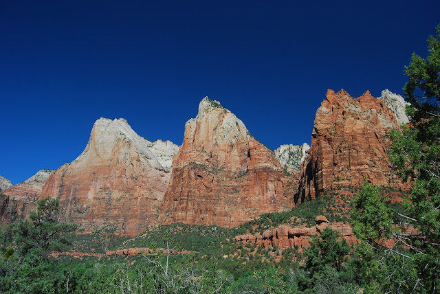
The Court of the Patriarchs

Our first lookout point was the Court of the Patriarchs. You'll notice from the photo above in particular that the top of the peaks are white and the lower rock layers are a deep red. It's pretty typical pattern for southern Utah and is as a result of the differing history of the area. Originally most of North America was a shallow ocean then as the tectonic plates moved around and collided with each other. It ended up being a huge plateau well over a 1000m above sea level.
The small river that cut this beautiful valley has created some incredible scenery. Above is the relatively (when compared with the Colorado River) small stream that has cut the Zion Valley. As a comparison, the Grand Canyon is roughly 1 mile (1.6kms) deep. The peaks above this little stream tower over a kilometre above us! It's quite the place.

Saddle Back

The red rock in the middle foreground is called Saddle Back. It's popular with hikers that like a bit of adventure. Directly behind it is the Great White Throne.

Emerald Pools

Our first short hike for the day was to the Emerald Pools. There are three pools in all. Lower, Middle and Upper Emerald pools. They're very imaginative with their names in America. The Middle Pools (below) run off a 10m cliff forming the waterfall above dropping into the Lower pool.
 

The pools themselves aren't that interesting, but the settings are pretty nice, particularly the Upper Pool (above) that has an incredible cliff face that towers above it (below).

The Weeping Rock


The Weeping Rock is another of the garden water features of the park. The water filters through the rock layers and falls off this ledge 100s of years later.

The River Walk

We messed up at Zion. Despite some good advice, I had thought that Emerald Pools was a "Must Do" but in fact it was the River Walk. By the time we got to it, the temperature was nudging 40C, we were all a bit dehydrated and some a bit sun burnt. Time was also our enemy as we had to see the northern section of the park on the way to Cedar City. We did go part the way along the path to the point where the path stops and the stream becomes the path. Considering how hot the ambient temperature was, the water was incredibly cold.

Virgin, UT

This oddity is something of a tourist attraction just outside the entrance of the main part of Zion Nation Park. It's odd to the point of being creepy.

Toquerville, UT


Yet another SW Utah anomaly. This is the rare North American Shoe Tree. This particular specimen is just near the town of Toquerville Utah. You've got to wonder who starts these things.

Kolob Canyon

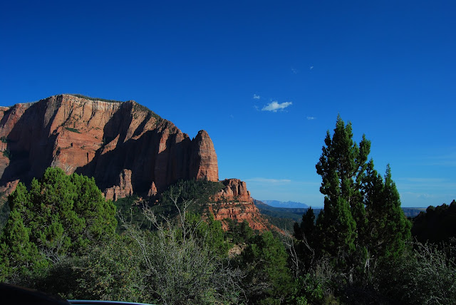
The north western part of Zion has a road that the public can drive all the way along, but rarely do. We reached Kolob Canyon late in the day and found it to be just as good as the main (southern) part of the park with less people.
Above and below makes up part of the view from the far end of the Kolob Canyon Road. We stayed for quiet some time to take in the view. It topped off a fantastic, if hot, day. I'd love to come back some day in the cooler months, do a few hikes and explore some more. What a great place!

Tuesday, 26 August 2008

The Grand Canyon - North Rim

This morning we all woke up bright and early to spend the day at the Grand Canyon. We had been to the South Rim back in January, this time we explored the North Rim.
The North rim is much harder for the regular tourist to get to and is closed during the winter (for about 6 months). Consequently it only receives 10% of the visitors compared with the South Rim. Suits me! Today we found out that the North Rim is by far the more spectacular of the two aspects. We had flown over it in a helicopter back in January, but today we had a closer look from the ground.

Bright Angel Point.

We started at Bright Angel Point near the visitor centre. You will notice that the nearby ridges are very close giving a much better feel for how deep the canyon really is.
For some reason Kerri (in particular) and Julie felt the need to find dangerous overhangs and climb out to have their photos taken. This was the first one in the Grand Canyon. Kerri had started the trend upstream at the Glen Canyon Dam viewpoint.
It is worth noting that the North Rim (2300m) is further above sea level than the South Rim (2100m). Despite that fact, there seems to be taller and more dense forests on the North Rim. There are exceptions and the trees closest to the edge of the canyon are beaten up the most (above).

Vista Encantada

This lookout point is called Vista Encantada. Back in January from the helicopter, we saw the Battle Ship covered in snow. In mid summer it is a very different look with the white ship sitting on the red rocks contrasted against green trees and blue skies.
At Vista Encantada, this guy was painting the spectacular view and doing a pretty good job too. He had quite an audience.
There's a road that runs along the North Rim for about 20 kms and along the way there are a number of view points to stop at (Vista Encantada is the first). A season or two ago, a wildfire ripped through a large part of the national park. The forest is just starting the long process of recovery. It made for a cool photo with the black, green, orange & blue.

Walhalla Overlook

This was another opportunity for Kerri to scare her mum. It was another of many beautiful view points along the way to Cape Royal. You can see the Colorado river in the background some 1.8 vertical kms below.

Cape Royal

Cape Royal was totally worth the drive. We spent quite a long time just sitting and admiring the view. This photo is only about a quarter of the panorama.

Angel's Window

 Yet another strange formation in the Grand Canyon National Park. Angel's window almost looks man made.

Point Imperial


Heading off in a different direction from the Cape Royal road, we came to Point Imperial. From there you can see across the plain toward Page and the upstream part of the Colorado River. Just in front of the lookout point is Mt Hayden (centre). Unfortunately the light was poor at that point because a serious electrical storm had just passed over. It had been a pattern for the previous few days. From lunchtime the clouds would build up amd then late in the afternoon a wild electrical storm would hit and dump a nice quenching dose of rain on the parched red countryside. It was just like summer afternoons growing up in Brisbane.
The Grand Canyon is one of those places that you really have to go and see before you "Check Out" of this world, but given a choice, go to the North Rim.

Vermilion Cliffs

On the way back to Page we descended the escarpment to the plain below. The photo above shows the view from about a quarter of the way down. Across the plain was part of the Vermilion Cliffs. It's one of the escarpments of the Grand Staircase that covers most of Southern Utah. The Vermilion Cliffs is the second bottom step and the Grand Canyon, the bottom. Tomorrow we are going to another step, Zion National Park.

Marble Canyon

Up at 2300m the thin air was relatively cool. By the time we had descended back down to the plain below, the ambient temperature (as shown by the gauge in the car) was close to 40C.
We had to cross back over the Colorado River at some point. The area is called Marble Canyon (below). At the narrow point there are two bridges. They are the old and new Navajo Bridges. The old one is to the left and had to be replaced because of the increase in traffic over the river. Part of the increase was heavier trucks. It's not exactly steeped in history, but cool looking bridges all the same.
It was a long day and by the time we finally caught sight of Page again, there wasn't much daylight left.