Tuesday, 7 October 2008

Lares Trek (Leg 3)


South America Day 13

The next morning we woke up to a white surprise. When we went to sleep I'd expected to wake up to more rain. Well the night must have got much colder because there was a couple of inches of snow that wasn't there when we went to bed. The rain had stopped and the winter wonderland that we'd become accustomed to in Canada had followed us into the heart of the Andes mountains.
The contrast from the horrible day previous, was astounding and very welcome.
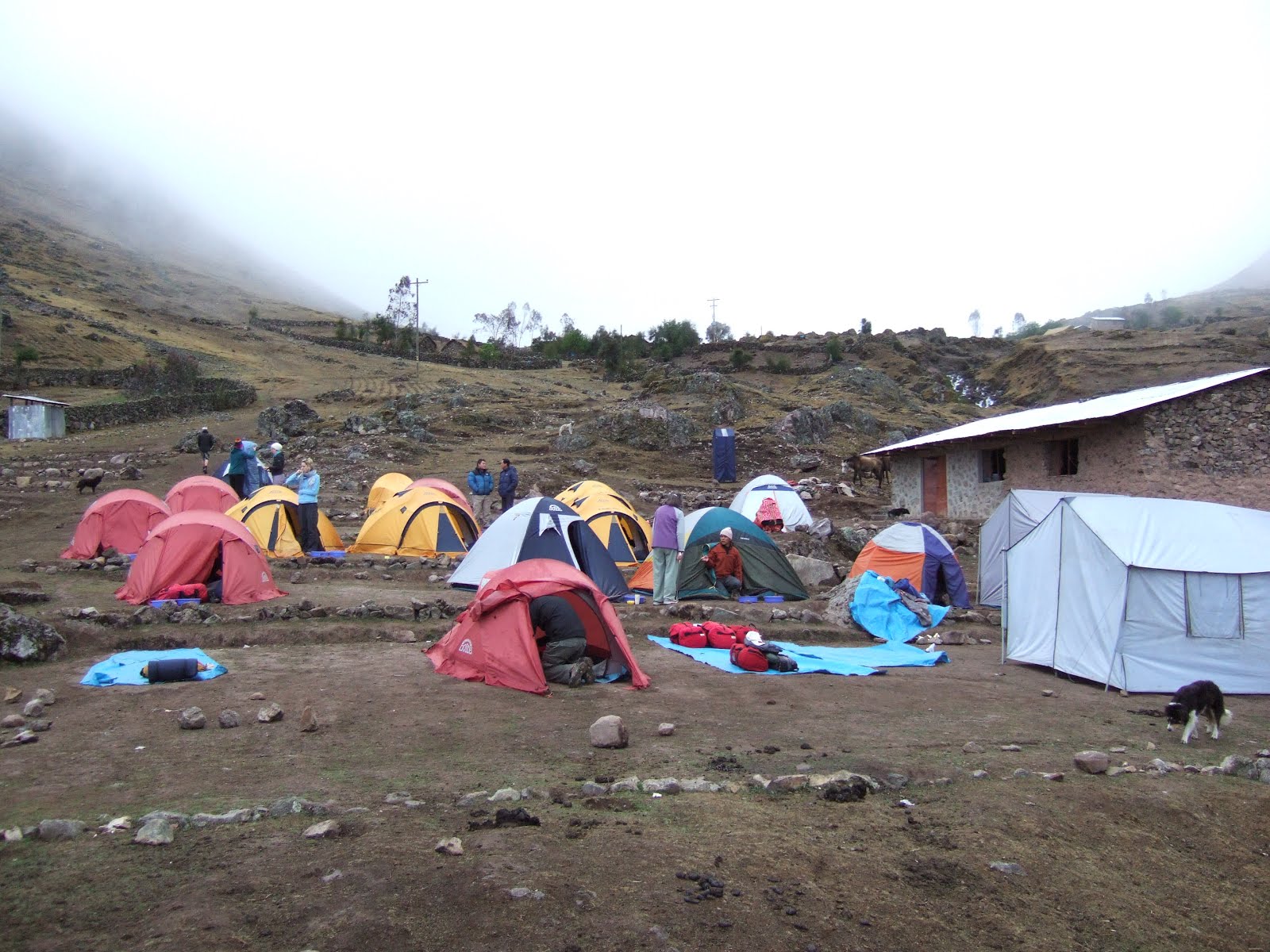
This is what we saw when we stuck our heads out of the tents. The air was still & crisp, the world had turned white. I'll let the photos tell the rest of the tale.


Here's our little mate who had followed us the previous day, Arfa (arf-a-tail). He probably slept in the cooking or dining tent during the night. Sure enough, he was there to greet us the next morning when we crawled out of our tents. He was particularly fond of Vixy for some reason (I'm guessing because she gave him snacks and didn't scald him like the rest of us). He was such a nice dog. It's just a shame he, like most of the dogs in South America are semi-stray at best.


Here are our two trek guides, José & Julio. Julio was the leader & José, his assistant (also our new favourite friend).
 
Of course there was time for on group photo with our cooks/porters/animal handlers before setting off for the last leg of the hike.
 
We packed our bags and, with sore muscles, started our descent toward the bus. The trail was slippery as hell thanks to the melting snow and mud. Picking our way down was going to be a bit more difficult than we had first thought.
 
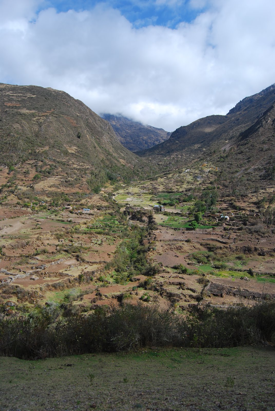
As the last leg of our trek continued down the valley, the snow started to dissipate as did the cloud. It turned out to be quite a nice day in the end.
 
The last part of the trek was almost uneventful.

The local children were all out playing on the hillsides (José was once one of these local children). Everyone gave away the toys that they'd bought in the market a couple of days previous.
The only incident of note was me going arse up after losing my footing on the trail around half a km away from the finish! It was very slippery all the way, but the trail started to incline sideways. I put all my weight on my left foot only to find it suddenly under my right side and then the ground was parallel instead of being perpendicular. I had mud all down the left side of my (only just) dry pants and my left shoulder was in a whole lot of hurt! I'd come down on my elbow and compressed my shoulder joint. I was OK, but my pride was severely damaged thanks to being at the head of the line so everyone saw me.
We made it finally despite the hardship over the previous 48hrs. I wouldn't say it was the best hike I've done, but because of the difficulties, we all had a sense of achievement.
The Finishers from left to right. Gemma, Mike, Vixy, Polly, Kerri, Emma, me, Melissa, Richard.
One further note. Thanks to some dodgy advice from a couple of the girls, Emma hiked the last day in her light blue pyjama bottoms because her hiking pants were wet. We laughed about it for some time after. We were so glad it was over....
We didn't get the chance to hike the Inca trail because by the time we'd booked, all the permits were issued. If given the chance take the Inca trail option. At least there's a result at the end and apparently the scenery is much more interesting with the last day of hiking through jungle.
 
 
Before we'd started out on our hike, Peru was about to go into a state of protest and blockade. Roberto had spent lengthy periods on the phone trying to organize alternate routes and accommodation to allow us to stay in Ollyentambo instead of somewhere way up the valley.
The Peruvians were striking and blockading the roads in order to bring the country to a standstill. Our problem was the blockade was going to make it difficult to get out of the little village we'd come to and would also make it hard to get to Ollyentambo to catch the train to Machu Picchu the next day.
 
Roberto managed to get us a night in Ollyentambo, so all we had to do was get back there. It turns out we'd come down a different valley to the normal route so that we could hike out if necessary. Lucky we didn't because it was about 16kms I'm told. The bus had come up early that day (or maybe the night before?) before the blockade, with another group who we passed earlier in the day. By the time we were on the road the blockade was in full swing.Despite the possible retributions, the porters & Jose jumped out of the bus where we came to a road block & cleared a path for the bus. These guys had been lugging gear for the last 3 days & they were still as energetic & happy as the day we set off. Mike chipped in to help as well as did I the first time before I realized that trying to help with a stuffed shoulder was useless & decided instead to stay in the bus with the girls.
 
We finally got our hot shower and a dry warm bed in Ollyentambo (not to mention convenience facilities). I can't tell you how welcome civilization was. We crashed and burned fairly early with an exciting day the next day with the day trip to Machu Picchu.

Monday, 6 October 2008

Lares Trek (Leg 2)


South America Day 12

During the first evening of the trek there was much talk about hardship on the hike and not signing up for this. We found out later the guides had concerns at that point about people not being able to make it. By the next morning there was a band of 5 heading back down to Lares. Vincent, Nora (who can be forgiven because the hike turned out to be far beyond their bodies' capabilities), Smita, Hina, and of course Special K, took the option to bail out. Each to their own. Our tour leader, Roberto, led them back down the valley to Lares to link up with a bus back to Ollyentambo.We headed off a little before the five, but quickly gained altitude. Before long they were little ants in the valley below (above). We survivors all seemed to be ticking along pretty well for the first while. Everyone was pretty up beat for the start of the biggest day of hiking.
 
The first section of trek day 2 was a steep ascent that transverses up the side of the valley. It's hard to show with a photo (above) but even with the traversing, the angle was pretty fierce. It was a bit of a challenge, but everyone was up for it.
 
Very quickly we climbed up into the clouds leaving the campsite far behind. You can kind of see it way off in the valley below (roughly centre of picture). It's surprising how quickly you can go when you put your mind to it.
 
As we pushed through Alt 4000m things suddenly started to get a bit more difficult. There seems to be a barrier right on 4000m where everything remotely resembling exercise hurts. Not long after that we stopped at a rocky outcrop for a break. It was quite the impressive outlook from up there. What wasn't so impressive was the view back up the hill toward where we were going. It looked like a never ending track upward. It was all the more daunting with the oxygen deprivation.
 
The last climb to the first summit of the day was quite difficult. The altitude claimed a few victims and caused the group to spread out quite a bit.
 
We eventually switched back one last time and were all of a sudden on the top of the ridge. Behind us far below was the valley we'd hiked from earlier that morning and in front of us were a pair of lakes. The wind and drizzle backed off long enough for us to appreciate the view for a few minutes. We were standing at 4150m above sea level.
 
Above is the second lake. It was down below us a little compared with the last one. Something to note in this photo is the path that we were about to take. It was to wind down past the lake, away to the left and down into the valley in front of us. Seemed like a good idea until the guide (Horacio) told us were we were headed. You'll be able to see the saddle in the range in the background about centre of shot. That was the target. We had to descend about 300m only to climb up the other side and add another 150m! This wasn't going to be easy.
 
We were still reasonably up beat when we started down the valley despite the altitude starting to take its toll on some. We set off with our camp right there in front of us on the mules. We knew they'd be there well before we arrived. My knees weren't liking the downhill much, but I wasn't too bothered. The group stayed together pretty well on the downhill as expected. Just as we hit the low point in the valley, the drizzle turned to rain and looked to be settling in. Not the best sign just when we were about to go vertical again.
The camera didn't come out much after that. The scenery disappeared behind the rain and the risk to the camera was too much. We stopped at a small village for a snack break. One of the local stray dogs (I nick named Arfa because he was missing half his tail) liked snack time and followed us for the next 24 hrs.
After the snack we trudged up the hill in driving rain, higher altitudes and ever dropping temperatures. Before long we were soaked to the bone from head to foot including gloves and boots. It was miserable. The next stop would be for a late lunch before the last push to the top.
Kerri was struggling as were a couple of the others and I elected to stay back with them and our assistant guide, (Jose') who we'd become quite friendly with by this point. The group quickly splintered as Horatio was setting a fairly solid pace leaving the people in the middle of the group in a lonely place. There were some cranky hikers trudging through the rain.
By the time we reached the tents at lunchtime, the will to continue was waning among the tail, but there was no turning back from there. Some hot food and a rest restored a bit of faith, but leaving the dry warm tent wasn't really very inviting.
 
We left the tent with the rain back to a drizzle initially. There were a flock of about 12 mountain caracaras (more later but they're a hawk of sorts) circling over us. I can't say it was an encouraging sign.
The trail was getting increasingly slippery the higher we went and the temperature was rapidly decreasing. Not long after we set off, the rain started again, but this time it was serious. The group scattered more quickly this time and finding the right trail became more difficult. The rain got heavier and eventually turned to sleet. Kerri wasn't impressed. Apparently princesses aren't meant to hike in mud in near zero temperatures at 4000m above sea level.
We eventually reached the summit in driving sleet with most of the group already at the campsite below us.
 
We were just thankful that the vertical ordeal was over and a hot meal and a sleeping bag were waiting for us. 20mins later we would be laying down in our tent.
A big thanks to Jose' (above in yellow) for his encouragement and patience with us particularly during the last couple of hours of that trying hike on that day.
We crashed and burned after dinner that night. We were exhausted. The night was a bit rough considering our gear was so wet and the tent made it worse every time we touched it.

Sunday, 5 October 2008

Lares Trek (Leg 1)


South America Day 11

I woke up still a little dodgy, but much better which was fortunate because we were about to start a 3 day hiking expedition.
Our first stop was the small town of Calca and the local markets for supplies. Calca is the gateway to the road to Lares (the start of our hike). The markets would allow us to buy toys and stuff for the children along our hike. For me, it was more about finding an inner sole for my recently repaired hiking boot. I was sent off with the assistant guide, Jose', who managed to find one nice and quick.
The road to Lares was long and windy. The photo above was taken from the high point as we crossed the ridge. I saw a condor briefly which was all very interesting, but the trip was still a bit tedious. The scenery was interesting enough.
 
The start of the trek was the hot springs just outside Lares. You can see the buildings in the background of the shot above. We got done big time by the guides (it was to become a pattern). We had nowhere to stop for "relief" along to long drive from Calca and with a bus full of girls, there was some desperation involved. The issue was that the only place to relieve ourselves was at the hot springs complex which cost quite a bit to enter regardless of whether we wanted to use the baths or not. Turns out the springs were a disgusting milky brown colour and  the locals seemed to have come to wash themselves in them. It wasn't at all inviting.
Never the less the cooks/porters cooked us up a nice lunch and we set off from the back of the hot springs complex across the bridge in picture. Again an opportunity for a group shot. This one had the entire clan but the shot at the end of the trek looked a little different.
 
We set off up the Lares Valley toward our first camp. It wasn't that difficult to start with as it was a fairly gentle incline. The hike in Colca Canyon some days earlier was harder. It was quite pleasant wandering beside the small stream.
 
Despite the easy going, we still seemed to spend a lot of time stopping and waiting for stragglers (this was the first). Special K was the first casualty and started the "I didn't sign up for this" saga. Actually she did sign up for this because it was pretty clear in the GAP trip description and difficulty rating. There we a few others that were finding it difficult while some of us were wondering how this was going to play out over the next few days.
Above is the view of the opposite side of the valley at our first rest stop. Although the incline wasn't too extreme, we'd been steadily gaining elevation.
 
  
Along the way there was no shortage of birds including this little humming bird. The purple flowers are apparently used a lot by the locals as a clothing dye.

Base Camp 1

We continued up the valley into the fading light at the end of the day. The stragglers were left behind with the trailing guide. As the light faded, the temperature dropped sharply and our core temperatures went with it. I thought I was getting a bit of a pinched nerve in my right arm from carrying the back pack and camera, but it turned out to be circulation.
As we reached the camp at Wakawasi we realized the porters and the mules had beaten us there. The tents were all pitched and dinner was in progress. My cold arm was more of a problem than I first thought and it took half an hour curled up in the sleeping bag to bring it back to normal. I've got to say I was worried for quite some time. Mental note for the next day to make sure I have warm gloves.
 

Saturday, 4 October 2008

Sacred Valley

South America Day 10

 
I successfully retrieved my boot only to realize the next morning they hadn't put the inner sole back. I'm a goose for not checking it when I picked it up, but I didn't want to hang around in that neighborhood too long.
We piled into a bus early on day 10, in my case reluctantly. I felt awful. My body was doing it's usual trick when I pick up a bug and went into high temperature and body shutdown mode.
Enough about my woes. We set off north of Cuzco past the Sacsayhuaman ruins and on to Sacred Valley (pictured). My recollections of that day are fuzzy to say the least so my comments will be scant. This photo covers only a small part of the valley that stretches some 25-30 kms.


Sponsored Village

The first stop in Sacred Valley was a small village that GAP sponsors to ensure that the local crafts aren't lost. Yet another tourist trap if you ask me. Kerri tells me the crafts were very expensive and the public toilets were disgusting. I have no comment on account of being out cold on the back seat of the bus loaded up with paracetamol during the stop.
 

Guinea Pig is a Peruvian delicacy. They look all cute and stuff, but you have to remember they're on the lunch menu. Dad calls them turners because they turn good food into shit.
 
I made it out of the bus for the Pisaq ruins and struggled along for the short walk. The local guide rambled on for some time about something I wasn't listening to (and I don't think anyone else was either). The tag line at the end had some sort of global warming message.....


I'd bypassed lunch that day so I could sleep & by the time we reached the Ollyentambo Ruins, I was trashed. The clan headed up to the ruins & the bus took me back down to the modern town of Ollyentambo where we were staying that night. I crashed out in bed and slept for a number of hours.
Kerri took a few photos while she was at the ruins including these ones. These are called the ten windows. Apparently there's some sort of acoustic phenomenon when you stick your head through one of the windows.


Above is the view back to the town where I was sound asleep, Ollyentambo. I surfaced later that evening and wandered around until I found Kerri and the others. I had dinner and crashed early. It was the worst day of the entire tour for me. It's a shame because I would have liked to have a better look around the Inca ruins in the area. I find ancient ruins so much more interesting than the replacement European buildings.

Friday, 3 October 2008

Cuzco

South America Day 9


Did I mention an early start? 4.20am! We had to be at the airport early for our flight to Cuzco. I think there are only 2 flights a day and our left at 6.50am meaning that we had to get organised early because of the group factor. The usual stragglers were slow getting off the mark again, obviously needing their beauty sleep (didn't work either ). We still managed to make the flight but breakfast was a tad rushed.
The flight wasn't direct. We touched down & swapped seats in Juliacca near Puno.

The flight from Juliacca to Cuzco gave us a look over the Altiplano with the volcanoes around Arequipa quite prominent. I've labelled a few of them. You can see how flat the Altiplano is which is hard to believe considering it's all well above 3000m above sea level. Most places around the world at that altitude tend to be a cluster of rugged snow capped mountain peaks. In contrast the Altiplano is a flat (relatively flat) dry desert.

This crazy twisted road was about the only other point of interest from the air. I have no idea how this is the easiest route to anywhere but the terrain around Cuzco is pretty rugged.
Eventually we made it to Cuzco in time for a late lunch.

Cuzco


Cuzco's a bit like Arequipa in that the buildings surrounding the main square (Plaza de Armas - for a change) had two levels with shops around the lower level & restaurants at the top. The buildings aren't anywhere as grand as Arequipa. Instead of the vast balconies, Cuzco has little balcony boxes. We took a punt with a pub of sorts that the three in shot (Mike, Nic & Polly) had come to. It turned out to be a fairly good call.

Cuzco's main square isn't as grand as the one in Arequipa, but it has it's charms. There's a Cathedral & a church. Pictured is the Cathedral. I like the bright coloured flower beds. Both the Cathedral & the Church have a real Spanish Gothic look to them.

Here's the Church in the Main square, La Compania. Not much to say about it. Just another church.

As mentioned before, Cuzco has these little timber balcony boxes instead of the vast verandas Arequipa has. It's very quaint.

The plan for the afternoon was to take a short uphill hike to the ruins of Sacsayhuaman (pronounced sexy woman, or close enough). We were to start the Lares trek the next day so a couple of hours wander would set us up for the 3 day trial ahead.
Cuzco was once the centre of the Incan empire before the Spaniards came along & trashed the place. The centre of Cuzco was Sacsayhuaman pictured here on the left hand hill above Plaza de Armas. It's a fairly steep climb to the ruins, but short enough not to be a drag. The right hand summit has a status of JC. Another legacy of the Catholic marauders.
On the way up the hill you have to clear the houses of the city via a seemingly endless set of stone steps.

Right at the upper boundary, there's a church, Santa Teresa, with a grand view of Cuzco. This photo is one of 3 I took to get a full panorama. The view from the ruins was even better.
Photographing the church we were standing in front of was pointless because it was shrouded by scaffold & plastic for renovations.

After a short but surprisingly tough climb, we reached the entrance to Sacsayhuaman. As for most tourist spots around the world, there was a ticket booth. We knew the scoop & bought the Tourist Pass that covered us for this & a number of other ruins around Cuzco & Sacred Valley, where we were headed the next day.Notice behind my sexy woman is one of many rock walls in the complex. The individual blocks are huge, but individually crafted to fit to the adjacent ones. Considering how massive the blocks are, the joints are almost air tight! They don't use mortar or fill the gaps with anything. It's shows the talents of the Incan people. The added interest is the fact that the Cuzco area gets regular earthquake visits & these walls are still as tight as they were centuries ago when they were constructed. Mean while, many of the European structures in the city below (including the Church & Cathedral mentioned before) have been destroyed & re-built more than once before.

The Incas were really quite civilized all things considering & their engineering feats are quite impressive. Think about how they managed to put that huge capping stone over the doorway. The Egyptians are renowned for moving big rocks around, but these people had a pretty good handle on it as well.The ruins look like the sands of time haven't been kind to them but the reality is that the Europeans dismantled it block by block & used the parts to build their churches & buildings down in the city below. It's kind of sad, but that's human nature for you.

90% of the South American population are Catholic & it shows. Standing at the high point of Sacsayhuaman, the ever present Christ the Redeemer was again a dominant feature of the landscape. It's lit at night so all the locals down in the city can see their saviour. It's kind of tacky really, but nothing you wouldn't see in Europe.

This view is more like what you'd expect to see at an Inca ruin. The terraces would have been for farming and even housing.

The terraces above are from where the previous shot was taken. It's a bit hard to get perspective, but believe me it's a pretty impressive structure considering the builders didn't have cranes or modern machinery.

Maybe this photo will cast some light on the situation. Check the huge rock to our left.
As you may have guessed, the Sacsayhuaman ruins impressed me. It's one of four within about 5 kms of this one.

The final comment from up on the hill at Sacsayhuaman is the view down to the city below. In the photo above you can see Plaza de Armas below with it's gardens & 2 churches.
We met up with Gemma & Emma from our tour group by chance & eventually headed back down to the hotel. I had started to feel the effects of the dodgy food at lunch the day before. It was the start of a couple of a horror 24 hrs for me & I wasn't alone. When I got back there were a couple of other casualties already hiding in their rooms.To make things worse, my faithful Merrel hiking shoes finally let me down. The toe on one of the boots came away from the sole 36 hrs before we were to hike for 3 days. Our tour guide Roberto took me down to the part of town that he'd told us earlier in the day, not to go to for emergency repairs. I was to go back & pick them up later that evening.