Sunday, 24 August 2008

Arches National Park

Yesterday we flew down to Salt Lake City in Utah with Kerri's sister, Julie. We had a few dramas getting out of Calgary airport together. Julie's incoming flight from London was delayed and ended up cutting it fine to catch the connecting flight with us. Kerri tried to go and find her only to be the one about to miss her flight.
Today is the start of a week long epic circuit of the southern Utah national parks. We're then going back to Cowtown to take Julie on a four day whirl wind tour of the Canadian Rocky Mountain Parks.

We went to pick up our hire car from the airport which should have been a 5 door hatch of some sort. We were asked if we would like an upgrade (as they normally do) but we declined. Lucky we did because the agent then said, "We don't have the type of car you ordered so were are giving you a free upgrade to an SUV."
"Well... Ok, I suppose so." I said. Then they asked me which one. I couldn't help but pick the 4Runner. James has one and I've taken a liking to it over the last 12 months. This will definitely make our trip way more comfortable.
The photo above was taken this morning outside our hotel in Salt Lake City where we stopped overnight. It was the beginning of our 2500km road trip among the red rocks of southern Utah.
We had to get moving early because the drive to Arches National Park is nearly 400kms. There isn't much of interestenroute and we saw a lot of terrain much like that in the photo above.

Arches National Park

Just before we reached Moab the terrain changed and, before we new it, were at the entrance of Arches National Park.

Courthouse Towers

From the park entrance at the southern extremity of the park, the road winds up between sheer cliffs for short while. At the summit Park Avenue (above) is the first marked feature we saw. You can walk its length down to where the road sweeps around to meet the other end of the Avenue. We chose to keep going because there was so much to see today. We have some time tomorrow morning to come back so we put it on the list for the morning when it is nice and cool.
Park Avenue meets the road just behind the Three Gossips (above). The Three Gossips are one of the more interesting formations in the park. Little explanation is required for the name of this formation. Sheep rock faces the Gossips (right of picture).
 Across the park access road from the Gossips is the Courthouse Towers. The Courthouse Towers seem a bit off track with the name to start with until you see the rock people at the top right of the feature.

Devil's Garden

After the initial excitement of some really interesting rock formations, we drove all the way out to the end of the northern access road that ends at the Devil's Garden (above). The garden contains three notable arches along with some impressive vertical faces that are only properly appreciated up close.
Just beyond the gateway is Tunnel Arch (above). If it was out in the middle of nowhere we would rave about for days after. Unfortunately, since there so many other amazing arches in the park, Tunnel Arch looses some of its grandeur.
Pine Tree arch is quite close to Tunnel arch and down the same side trail. As impressive as it is, in the context of Arches National Park, it rates as average. There is a small, weather beaten pine tree under the arch.
We back tracked along the side trail and saw a few puffs of cloud building up. We thought nothing of it at the time as it was getting pretty hot and we were in the middle of the US in a desert. More on that thought later.
This was a very abstract formation. It looks like the elongated face.
We didn't have time to hike the whole trail but we did make it to Landscape arch (above). Landscape Arch was one of my favourites today. The surrounding 'Landscape' frames the arch with longest span of any of the arches (88m).
By the time we passed back through the gateway the sun had made its mark. We all had varying degrees of sun burn and were already getting dehydrated. Back at the car we applied sunscreen and filed our water bottles.
Back tracking south along the road, we made a stop for Skyline Arch. It is one of the more picturesque arches and the sunny skies gave us the most incredible azure skies to offset against the burnt orange coloured rock formations.

Fiery Furnace

Delicate Arch

We were heading for the road junction in the middle of the park so we could take the eastern road out to Delicate Arch. A mile or so from the junction is the Fiery Furnace (above). I have absolutely no idea how the rocks formed over time in this park but they're nothing like anything I've seen in my travels.

To get a view of Delicate Arch, you have to take a short but steep trail up to a lookout point. The reward is obvious. Delicate arch is probably the most spectacular of the arches in the park. It The picture above with taken with a 300mm zoom lens and the scale of it is very hard to gauge without some sort of reference. There are two people in the photo to put some sort of perspective to it.

In the photo above, Delicate Arch is that little arch the the top left of shot. The enormity of the rock formations in the park really challenge the mind. It's well worth sitting at the lookout point for a few minutes to appreciate the surrounds.

Balanced Rock

From Delicate Arch we pressed back toward the middle of the park. Balanced Rock marks the spot in what appears to be slap bang in the middle of the park. It is one of the highest places in Arches NP so it seems appropriate. At that point we became more aware of the building storm clouds. It gave us a sense of urgency to keep moving. Despite that, we couldn't help but take a few silly tourist shots.

 Garden of Eden

From Balanced Rock we headed for the Windows Section. About half way we stopped at the Garden of Eden. I'm not too sure where they got the name for this one but whatever the reason, I like the lone soldier sentry looking out over the park.

The Windows Section

The Windows section is a cluster of impressive formations. As you approach, Cove Arch (above) comes into full view.
The Parade of Elephants. Kind of... The photo below makes it a bit more obvious.
Cove of caves.
 Again, nothing too cryptic about the name for this one. Alone they are know as the North window & South Window. Together they are called the Spectacles. We went for a wander/scramble through the specs and Turret Arch.

Turret arch (above) is directly opposite the Spectacles. It is about the best place to take photos of the Spectacles.
Double Arch.
Double arch is in fact the one the the far left of picture. The second arch is set behind the one you can see & makes a V shape if you looked at it from above. We would have gone for a walk to get a better look but thought better of it. It was at the end of the day, it was pushing 40 Celsius, there was a nasty thunderstorm baring down on us and we were a bit arched out to be honest. The heat was making everyone a bit narky so we decided it would be best to head for the hotel. It was a good thing we did because the heavens opened shortly after and quenched the parched desert landscape.
We stayed the night in the small town of Moab. Judging by the vehicles parked in the main street the area is a magnet for serious four wheel drivers. We had a nice Mexican dinner before turning in for the night.

Sunday, 17 August 2008

Spray Lakes

We were still buzzing this morning after our day at O'Hara. It was a clear day and we decided to give Spray Lakes another look. Our previous attempts had been marred with bitterly cold winds, snow & iced over lakes.
 The weather cooperated nicely but the exercise clarified a couple of things. Kananaskis Country is very much the domain of the fisherman, water skier or quad biker. And the mountains look very grey and dusty in summer with the snow gone.
We couldn't quite understand where Mud Lake got its name. Today it became blatantly obvious (above).
And back to Cowtown we went. We're off to the US again next week. Julie is coming over from London to join us.

Saturday, 16 August 2008

Lake O'Hara

Today was one of those days in the mountains that we will talk about for years to come.
Lake O'Hara sits right on the border between Alberta and British Columbia. If you were to hike over the glacier at the back of Lake Louise, you would find yourself overlooking Lake O'Hara. In a bizarre twist, most of the locals (Calgarians) have no idea what so ever where it is or that it even exists. It suits me fine. It's a bit different to many of the other heavily populated sights in the Rocky Mountain Parks and for a good reason. The Lake O'Hara Basin is an important wildlife corridor so Parks Canada limit the number of people in the area each day. Private vehicle and tour buses aren't allowed past the car park 11 kms down the valley. The only way to get there is to hike in, or catch one of the limited O'Hara buses into the area. We booked our seats on the bus 3 months ago.
We were on the 8.30 bus and set off for our day hike in the area. The original plan was to hike the 2.8 kms around the lake & then up to the Opabin Plateau some 250m above Lake O'Hara. The lake shore was in shade early on and made photography challenging to say the least. Some turned out fairly well.
 Lake O'Hara's outlet stream.
 Wiwaxy Peaks

We decided that it would be better to climb the trail up to the plateau while it was still nice and cool. It turned out to be a good call.
Mary Lake
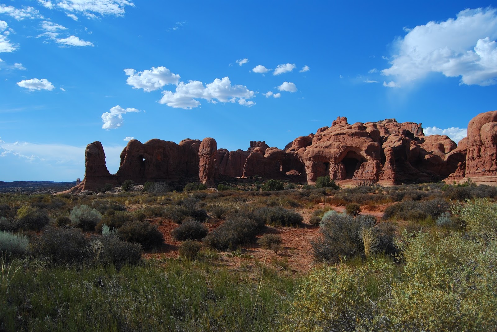
We passed Mary Lake just after leaving the Lake O'Hara circuit. Mary Lake sits beside Lake O'Hara separated only by a thin line of trees. As we climbed, the views of the O'Hara Basin became more and more picturesque. We we started to catch glimpses of Mary Lake by the time we were a quarter of the way up the climb. By half way up we were treated to the view above. To the left is Odaray Mountain; centre is Cathedral Mountain and to the right is Wiwaxy Peaks. Lake O'Hara was still obstructed to the right of shot.
Near to the top of the climb, I spotted one of my fury little friends that have seemed to follow me around this year. The marmot wasn't alone either. Her young one was with her. I managed to get a picturesque shot with the two animals on the rock in front of me.
Just in case your eyes aren't so great, here's a close up of the fury little family.
The only thing that marred our day in the alpine region was the mosquitoes and horse flies. You can see the 4 mozzies around the marmot. As soon as we stopped moving, the little blighters were on us! The other pests were the horse flies. The Canadian locals reading would be well aware of these aggressive insects, but for the readers down under, the Canadian horse fly is as close to a march fly as you are going to get and bite just as hard!
After the climb up the escarpment, this is the pay off. What a fantastic view!! The rock ledge at the top of the cliff has totally unobstructed views of the O'Hara Basin.
The view includes the three mountain peaks I mentioned before plus Mary Lake & beautiful Lake O'Hara (turquoise lake to the right). The area between the lakes & the distant Cathedral Mountain is a no people zone to allow the wildlife to feed & migrate in peace. Great idea! Canadians take their natural resources for granted & There should be more of this in the mountains, particularly in B.C.
Lake O'Hara & Wiwaxy Peaks
At one point I was thinking I was a big girl's blouse for not wanting to walk out on the ledge that Kerri is standing on in this photo. I found out soon after I took this shot that a the time, she had no idea how far down it was from this shear ledge. I'm pretty sure she wouldn't have gone out there if she'd known.

The Opabin Plateau

The Opabin Plateau is approximately 2200m above sea level. The vegetation is quite different at that elevation. The dense spruce forest gives way to open larch groves (above). The sparse forest allows you to see more of the surrounding scenery. Once the Fall hits, the needles on the larch trees turn golden and make for fantastic photography opportunities (apparently).
To me it doesn't really matter. The amazing sights we saw today were brilliant regardless of the colour of the larch needles. The peak in the background is called Mount Huber.
 The Opabin Plateau was so different to anything I've seen so far in Canada. I'm sure it's not unique, but there don't appear to be any places like it that are so accessible.
The Opabin Plateau has the full set of tricks. Aside from the larch forests, it has streams, small waterfalls, ponds, lakes, shear cliff walls grassy meadows, rocky outcrops... Everywhere you turn, there's something else to take in.
We spent a few hours wandering around the plateau checking out all that we could find. I'm pretty sure we missed a few things as well. Most of the streams & lakes had the typical Rocky Mountain turquoise tint to them.

Lake Hungabee

After we'd wandered around for a while we reached Hungabee Lake toward the head of the valley (foreground). We headed up the last incline to our ultimate destination, Opabin Lake. (below).Once again you can see Odaray Mountain, Cathedral Mountain & Wiwaxy Peaks. You'll also notice another 3 little lakes down the valley from Hungabee.

Opabin Lake

Another lake and another pretty setting. Opabin Lake was the highest of the lakes we visited (2285m above sea level). The peak at centre is Hungabee Mountain & just to the left of that Ringrose Peak.
In order to not retrace our steps and, more importantly, see everything we could, we took the east trail back toward Lake O'Hara, the East Opabin Plateau Trail. The photo above is the start of it next to Opabin Lake.
We stopped for lunch just down the hill from Opabin Lake. The dining view is pretty hard to beat, don't you think? Again the lake in the foreground is Hungabee.
This imposing wall was visible pretty much all the time we were walking around the Opabin Plateau. Unless you're actually there it's difficult to put it's shear size into perspective. (Hungabee Lake in the foreground again).
Even the most insignificant pond was an opportunity for a postcard shot.

Lake O'Hara

The above photos is most certainly not the pick of the photos for the day, but it allows me to tell explain our day's adventure. The bump in the middle of shot is Opabin Prospect. We started the day by hiking up it's right side and returned to Lake O'Hara to the left. We had overlooked the entire valley from the top middle.
Postcards, fridge magnets and calendar photos of Lake O'Hara are little scarce because it's unknown to the mainstream tourist rabble. This one is about as close to a "Lake O'Hara" tourist shot as you will see. The only flaw in the picture is me!
After the decent from the Opabin Plateau, we followed the Lake O'Hara shoreline back to the Lodge. All the way around, the scenery was ever changing & no less interesting than what we'd seen earlier in the day.
The lake trail is the busiest in the area but some of the wildlife was still willing to greet us. This chipmunk was too focused on collecting pine nuts than wondering about what we were up to.
Across Lake O'Hara in the photo above, you will notice a few cabins. They are part of the Lake O'Hara Lodge. There are only a dozen or so cabins in the complex and cost about $500 CAD per night. Despite the high cost, they are very popular and you basically have to book a year ahead.

Here's another shot of Lake O'Hara's outlet stream. I'm always astounded by how much different times of day and lighting conditions can change the scenery.
After 10 kms & 5-1/2 hours of hiking, we were back at the place we started. And guess what? Another great photo opportunity! Who would have thought??
We had enough time before our return bus to explore down the hill a little. There wasn't much of interest where we went but we didn't have time to venture further toward Cathedral Mountain.
The locals were keeping a close eye on our movements.

If you are ever in the Canadian Rockies (in summer), set aside a day to explore this beautiful part of the world. You won't be disappointed.

Friday, 15 August 2008

Moraine Lake

Today we set off for the mountains after work because we have an early start in Yoho National Park in the morning. We're staying at Lake Louise so we don't have to drive far either. The long days allowed a sneaky sunset drive out to Moraine Lake. We haven't been there at dusk before and it has a very different and peaceful feel late in the day.
The opportunist golden-mantled ground squirrels are still out and about in case a visitor has a snack.

Saturday, 9 August 2008

Hawk Spotting

Today was one of those days when I drop Kerri at work, fuel the car up and drive into the middle of nowhere with my trusty camera looking for wildlife.
Swainson's Hawk
The long summer days and lack of snow means that the mammals are scarce, but the birds are about. There were loads of raptors this morning. It was a bit cooler so they didn't take to the air until a bit later than they have done recently.
There was plenty of variety as well. They all seemed to be sitting on fence posts waiting for the land to heat up and get the thermals working.
It filled in the morning satisfactorily.